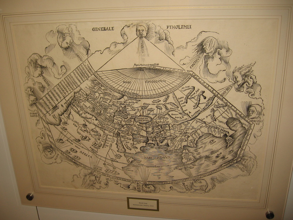
World Map (Ptolemy), Johann Schnitzer, 1482 or 1486.
I was surprised to learn recently that a world-class map museum is located in San Diego. The Map and Atlas Museum of La Jolla is considered to be one of the best dedicated map museums in the entire world!
Out of curiosity, I swung by the small museum yesterday and lingered for at least an hour. I could have spent the entire day looking at the amazing collection of historical maps that fill several themed galleries.
Many of the rare maps are antique, dating from centuries ago when the world’s outlines were unknown, and sea monsters inhabited the watery margins. Every map in the collection is original and authentic, including the first map ever printed!
As I stepped through the door I was greeted by Richard, the friendly director of the museum. I learned that this free museum was founded by Michael Stone, a local businessman and collector with a love for maps. In his youth he collected baseball cards, stamps and coins, before maps and cartography became his passion. At any given time, about ten percent of his vast collection is on display. I was told that Michael is one of the top half dozen map collectors in the world.
There are antique maps showing Earth as the center of Creation, maps from the Age of Exploration, maps from the Revolutionary War, Victorian maps, tourist maps, even maps showing early San Diego. There’s a woodcut map that was created by Benjamin Franklin! There are artistic maps, humorous maps, playing card maps, practically every variety of map or atlas ever conceived by the human mind. There are also historical instruments used by the old explorers and map makers.
For history lovers, the Map and Atlas Museum of La Jolla is a jaw-dropping delight! Visitors might feel they’ve stepped into the vaults of the Smithsonian or National Archives. The collection is that extraordinary!
Richard wandered about the museum during my visit, greeting people and providing tidbits of fascinating information. He informed me many students come by the museum, where they can study history, cartography, design and art.
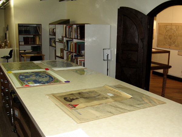
The museum contains such an abundance of cool stuff, I don’t know where to possibly begin. To provide an idea of what you will see, I offer a sampling of photos. I’ve roughly arranged these maps in chronological order. Read the captions!
In my opinion, this little-known attraction in San Diego is an absolute must see! You can find it in the lower courtyard level of the office building at 7825 Fay Avenue in La Jolla. Check out their website for hours and more info, including special exhibitions.
Visitors look at an amazing collection of historic maps at the Map and Atlas Museum of La Jolla.I was shown the museum’s work room, containing a library of books that the public can access. A variety of museum projects like the scanning of maps and historical documents is also done here.
The following is a tiny sample of the many original, rare maps you’ll see when you visit the museum:
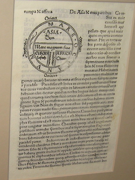
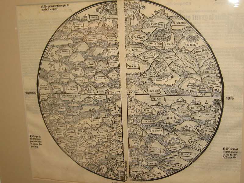
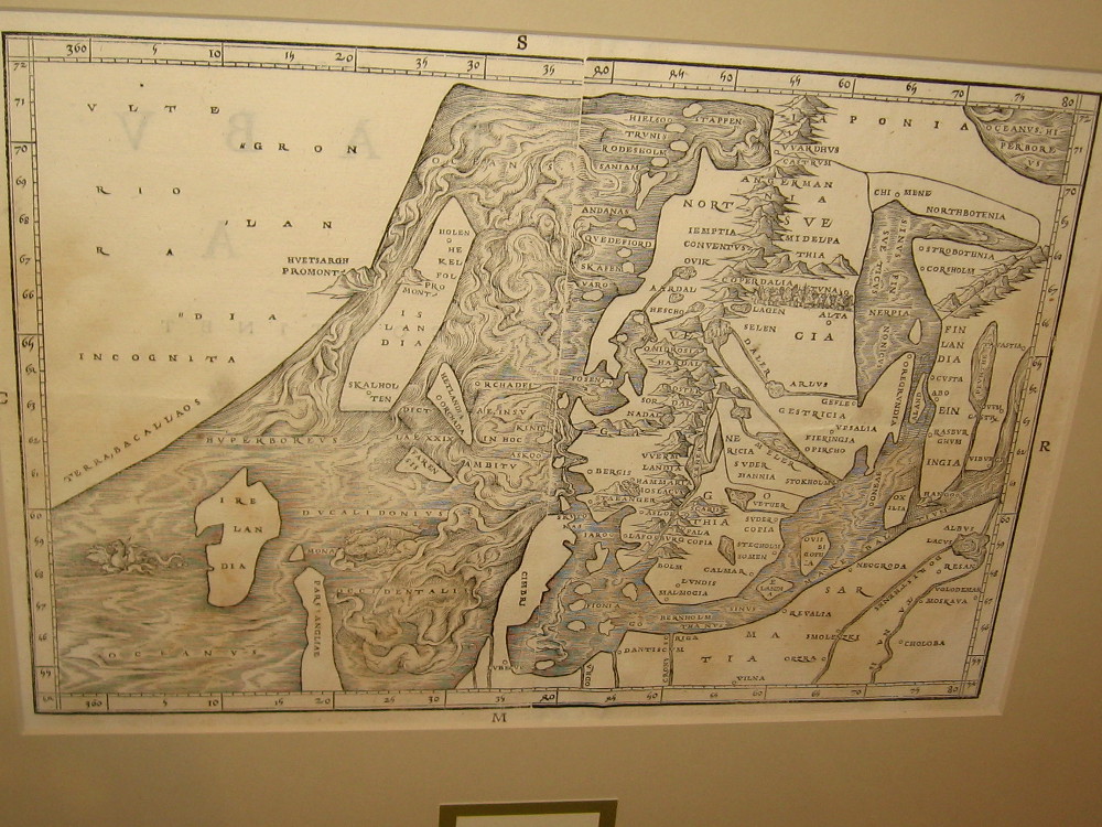
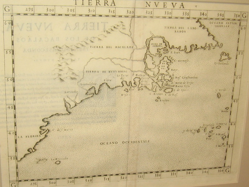
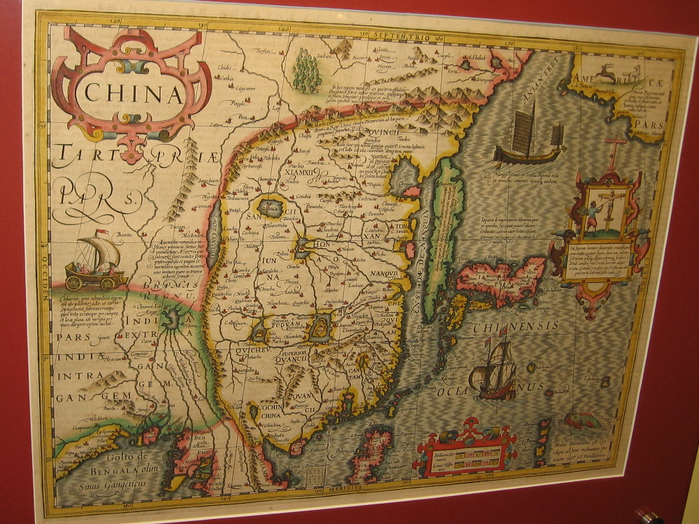
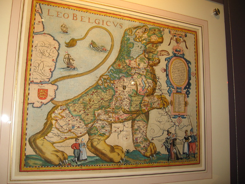
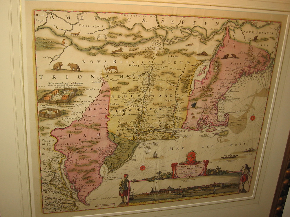
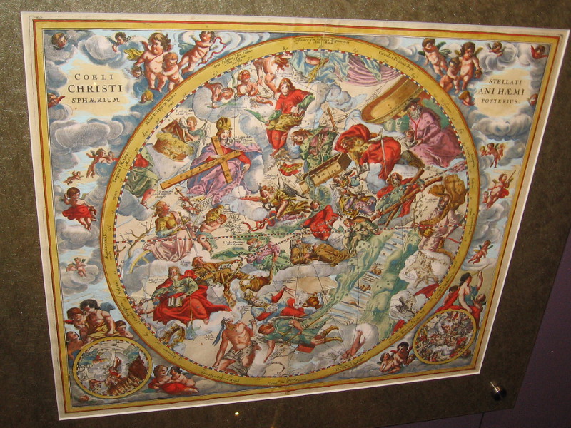
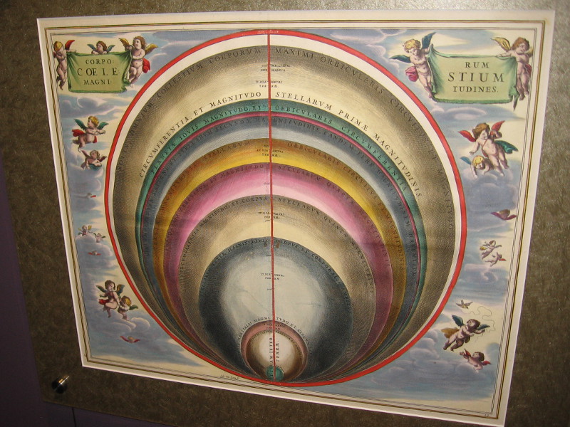
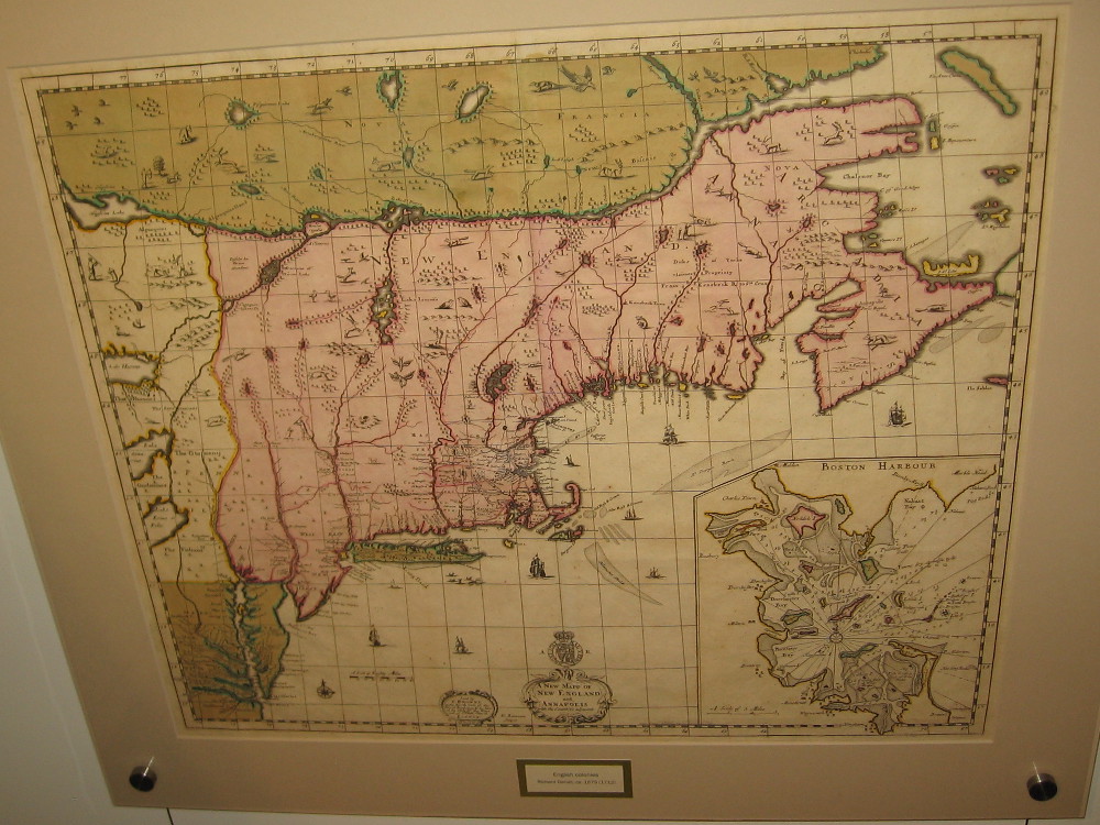
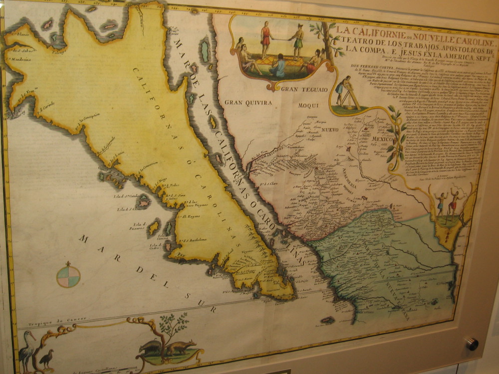
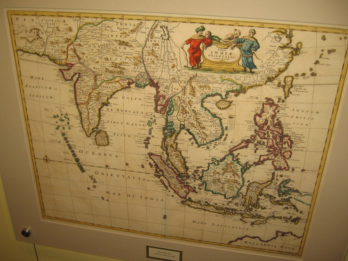
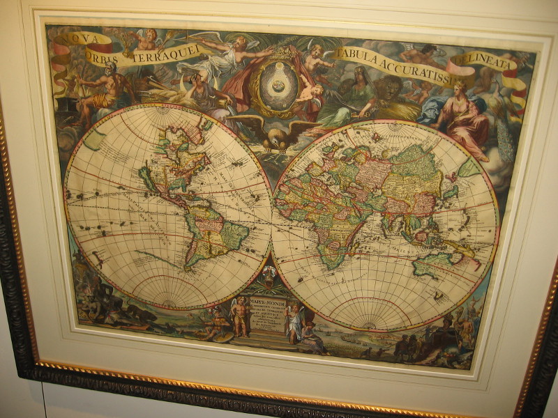
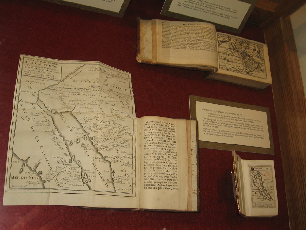
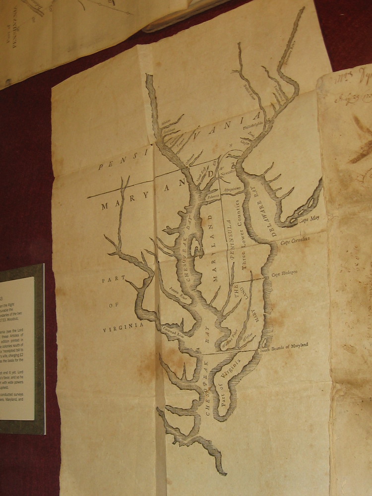
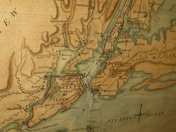
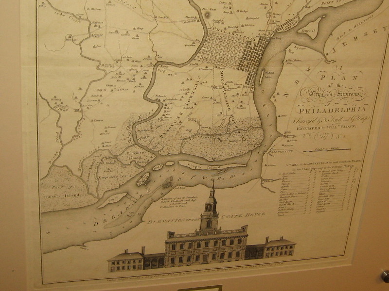
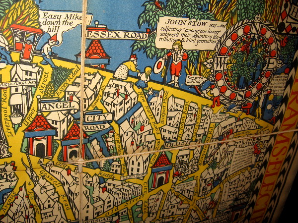
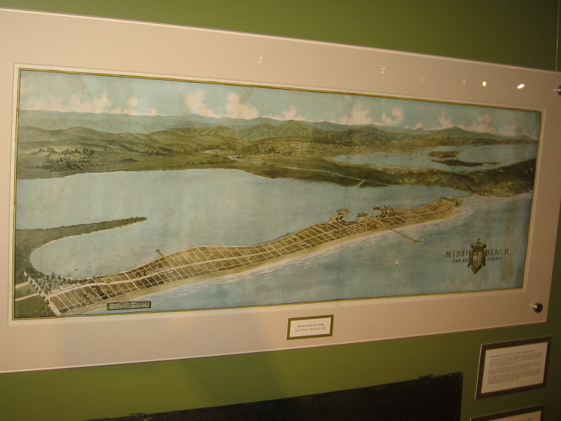
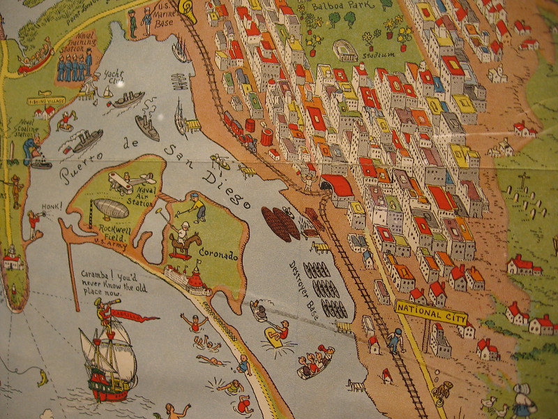
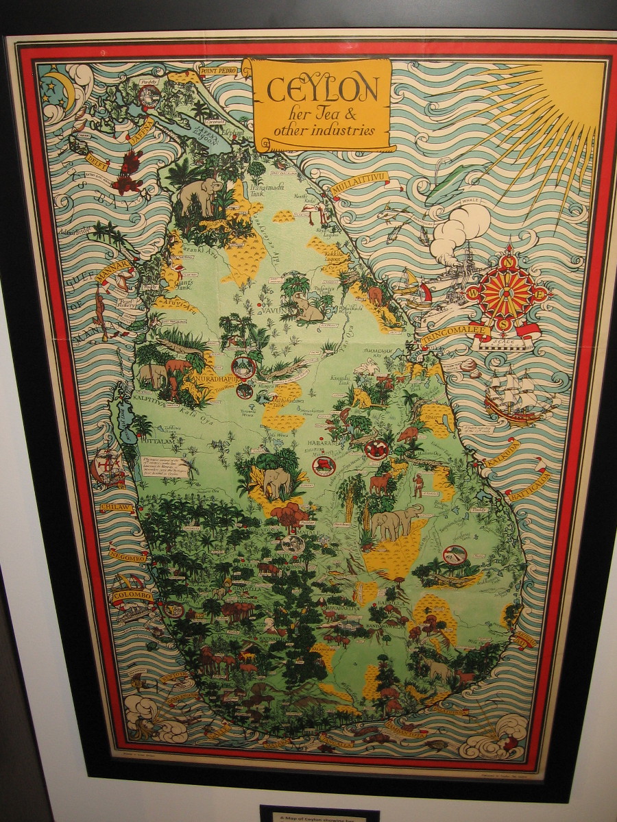
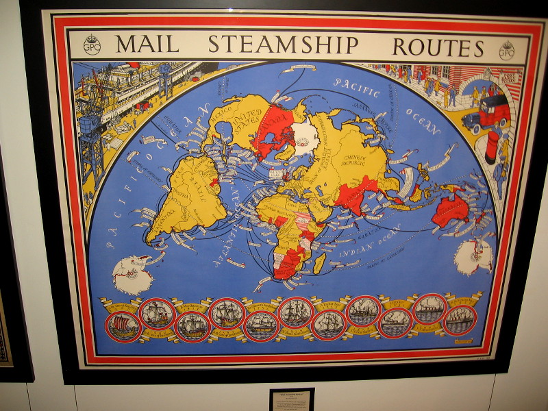
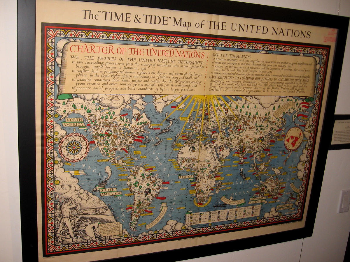
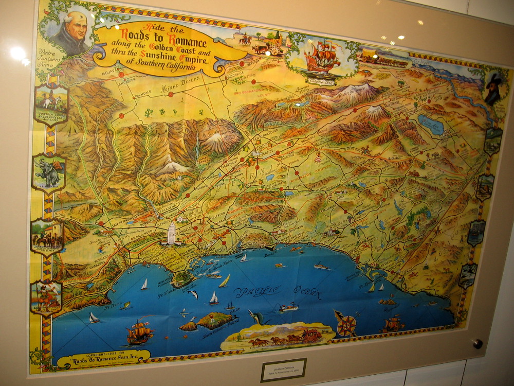
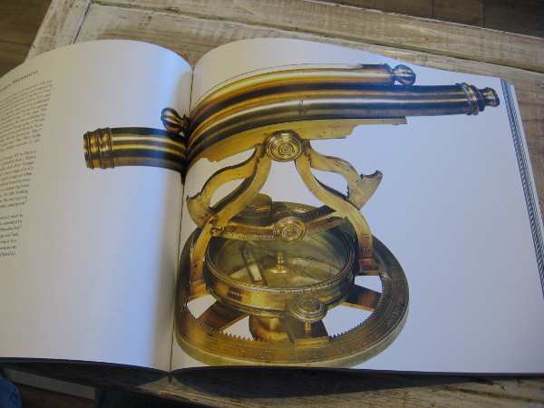
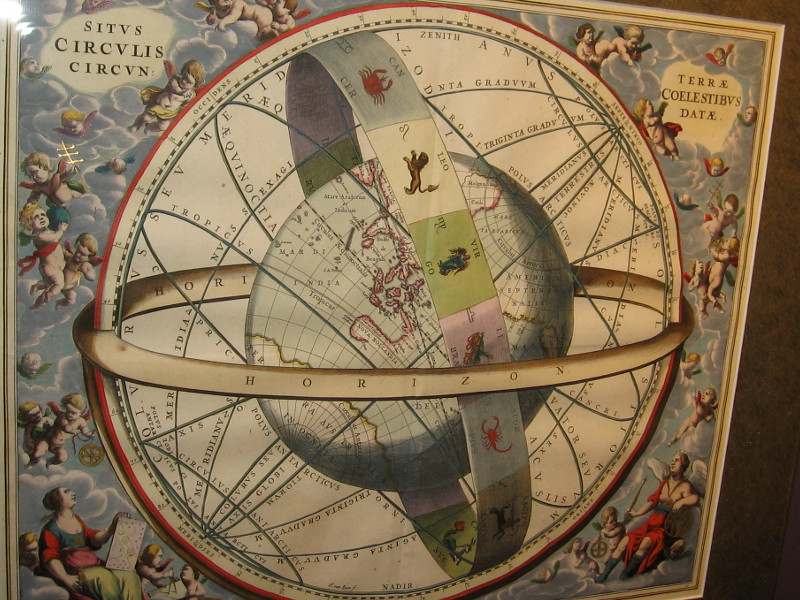
The world’s first printed map of a certain date, 1472. This woodcut T-O shaped world map is from Isidorus Hispalensis (Isidore of Seville).World Map, anonymous, 1491. This map was often hung in medieval monasteries or palaces. It first appeared in the Rudimentum Novitiorum of 1475.World Map (Ptolemy), Martin Waldseemuller, 1513. Even after the discovery of America, Ptolemaic maps devoid of a Western Hemisphere were still printed.North Atlantic, Jacob Ziegler, 1532. Information for this map was obtained from two Archbishops in Rome. Newfoundland is Terra Bacallaos, or land of codfish.America, Sebastian Munster, Basle, 1540. This depiction of North America came from reports by explorer Giovanni da Verrazano.Eastern North America, Girolamo Ruscelli, 1561. Little was known about the inland geography.North America, Paolo Forlani, 1565. A map that shows America and Asia separated with a strait.China, Japan and Korea, Jodocus Hondius, 1606. Copperplate engraving from the Mercator Atlas.View of Macao, Theodore de Bry, 1607. A stylized map, the first published image of Macao.The Low Countries in the Form of a Lion, Petrus Kaerius, 1617. A map of the Netherlands and Belgium.Northeast North America, Jan Jansson and Nicholas Visscher, 1655.Second Hemisphere with the Christianized firmament, Andreas Cellarius, 1660. The twelve apostles supplanted the old zodiacal constellations in this map.The Sizes of the Celestial Bodies, Andreas Cellarius, 1660. The heavenly bodies compared with Earth, according to Ptolemy.English colonies, Richard Daniel, ca. 1679. The first printed map of the colonies depicting roads.California on early maps was depicted as an island.Southern and Southeast Asia, Frederick de Wit, ca. 1680. A standard Dutch published map.Eastern North America, Hermann Moll, 1715. Beautiful illustration on what is commonly called the beaver map, which was copied from an earlier 1698 map by Nicolas de Fer.Nova Orbis Terraquei Tabula Accuratissime Delineata, Pieter Van Der Aa, 1713. I love the extensive Latin name given to this highly ornate copper-plate engraving Dutch map!A display case at the Map and Atlas Museum of La Jolla includes geographic playing cards from the early 18th century.Chesapeake and Delaware Bays, Benjamin Franklin, 1733. Franklin likely cut the woodblock himself. The map shows the newly delineated boundaries of Maryland and Pennsylvania.Battle of Long Island, Samuel Holland, 1776. A section of a map that shows the plan of the first major battle in the American Revolution.New Jersey and Pennsylvania, William Faden, 1777. Plan of the Operations of General Washington, against the King’s Troops in New Jersey.Philadelphia, William Faden, 1777. Lower half of the map includes copy of the earliest known printed image of Independence Hall.The Wonderground Map of London Town, MacDonald Gill, 1915. This small section shows some of the delightful retail map’s humor.Mission Beach, San Diego, 1915. Map of the projected development of Mission Beach.San Diego, Joseph Jacinto Mora, 1928. Corner of a map containing illustrations of local history and important places, like the pictured Union Station (now Santa Fe Depot), Horton House (where the U.S. Grant Hotel stands today), Army and Navy YMCA, and Casa de Estudillo in Old Town, which was then called Ramona’s Marriage Place.Another section of the same map showing areas around San Diego Bay including downtown, National City, Coronado and Point Loma.A Map of Ceylon showing her Tea and Other Industries, MacDonald Gill, ca. 1934.Mail Steamship Routes, MacDonald Gill, 1937.The Time and Tide Map of the United Nations, MacDonald Gill, 1948.Southern California, Roads To Romance, a tourist map ca. 1958.Thomas Jefferys’ brass theodolite, part of the museum’s collection. Jefferys was geographer to King George III. The antique theodolite is pictured in the extraordinary book The Cartographical Collection of Michael R. Stone.The Location of the Earth, Encircled by the Celestial Circles, Andreas Cellarius, 1660.
…
I live in downtown San Diego and love to walk around with my camera! You can follow Cool San Diego Sights via Facebook or Twitter!
You can easily explore Cool San Diego Sights by using the search box on my blog’s sidebar. Or click a tag! There are thousands upon thousands of photos for you to enjoy!
Expecting to Fly (for the Zeros), Fred Tomaselli, 2013.
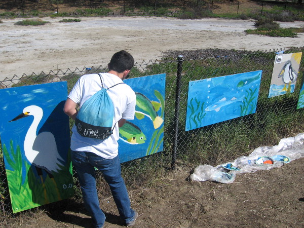
You might remember I posted photos of street art and many of the Murals of La Jolla a couple years ago. You can see all of that fun artwork by clicking here. Sadly, a couple of those murals no longer exist.
My adventure today included passing by even more public art murals, plus some beautiful and inspirational stuff that I found while journeying down sidewalks.
I snapped a great map and legend of the Murals of La Jolla in front of the Museum of Contemporary Art San Diego on Prospect Street, which is undergoing a renovation. To see the location of all the current murals, which include some that I photographed in that earlier blog post, click the map below and it will enlarge.
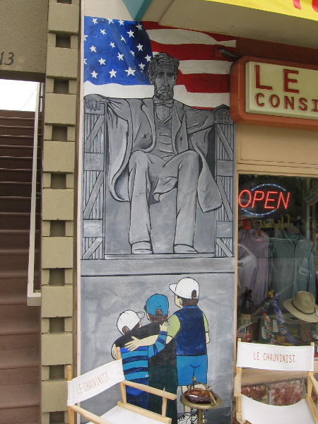
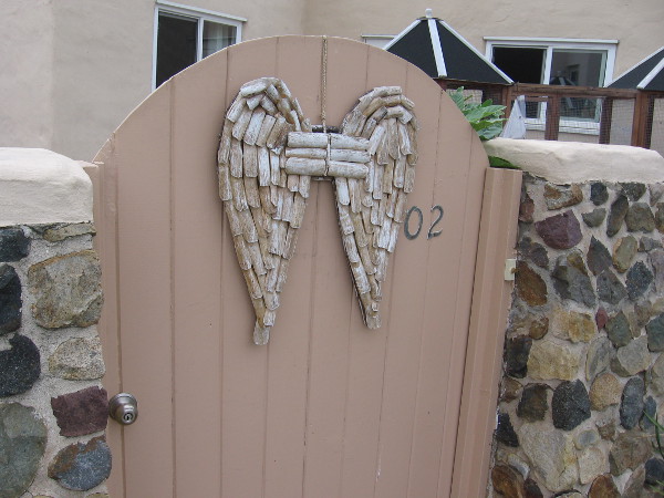
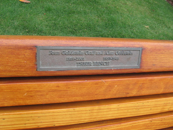
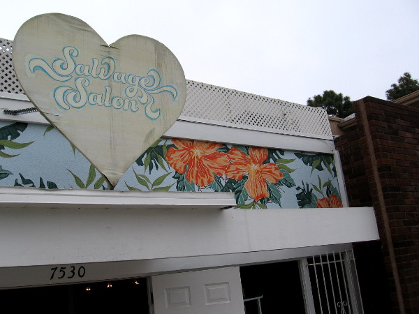
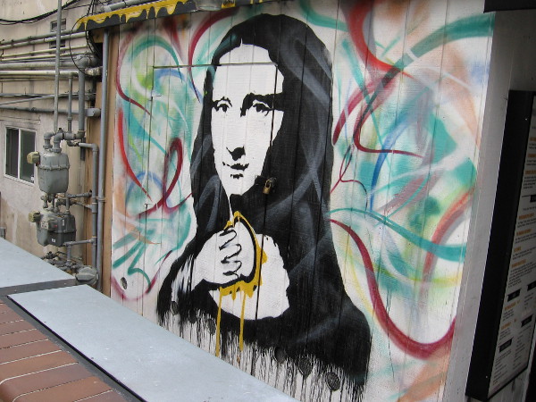
Map and legend that you can use to locate the many amazing Murals of La Jolla.Playing La Jolla (for all it’s worth), Terry Allen, 2015.Suns, Victoria Fu and Byron Kim, 2016.Man, Myth and Magic, Steven Hull, 2017.Art near entrance of Le Chauvinist depicts three kids at the Lincoln Memorial.A fish etched in the concrete sidewalk near El Pescador Fish Market!Angel wings on a gate.One of the most stunning gates I’ve ever seen. Shining golden leaves and blooms seem to grow through it.By the sidewalk… Joan Goldstein Graf and Alan Goldstein. Their bench.Painted flowers near the roof of Salvage Salon.Come into my garden so my flowers can meet you.A very cool mural in the alley next to the Grater grilled cheese shop in La Jolla.It appears Mona Lisa has a taste for grilled cheese sandwiches!
…
This blog now features thousands of photos around San Diego! Are you curious? There’s lots of cool stuff to check out!
Here’s the Cool San Diego Sights main page, where you can read the most current blog posts. If you’re using a phone or small mobile device, click those three parallel lines up at the top–that opens up my website’s sidebar, where you’ll see the most popular posts, a search box, and more!
To enjoy future posts, you can also “like” Cool San Diego Sights on Facebook or follow me on Twitter.
A clean, beautiful city by San Diego Bay, painted on the side of a building in Little Italy.
Yesterday morning, as I walked through Little Italy to photograph that cool Mona Lisa freeway on-ramp mural (my previous blog post), I discovered some additional artwork in the vicinity of State Street and Fir Street.
The large mural on the side of a residential building is clearly seen by motorists heading down Interstate 5. It contains a positive message. Colorful scenes encourage people to get out of their cars and jump on a bicycle or public transit.
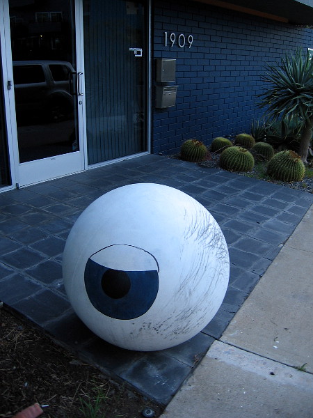
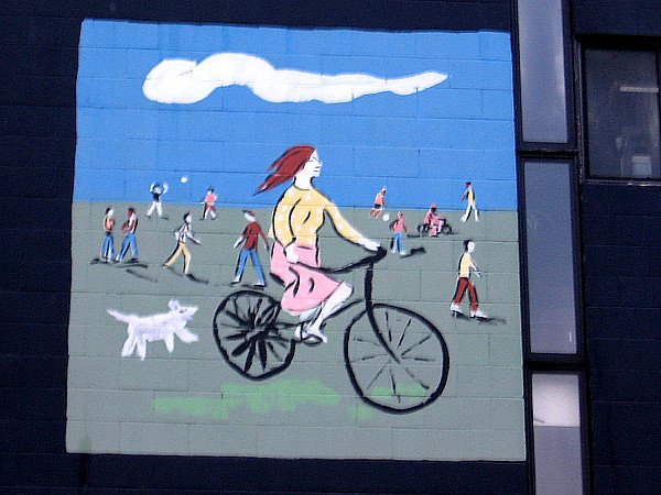
A large, dynamic mural on a building that can be seen from nearby Interstate 5. Images convey an environmental message, encouraging bike riding and public transit.Mural on side of Porto Vista Hotel shows reflections of sailboat masts in blue water.A big eyeball near the entrance of the Landscape Architecture business Environs.Riding a bicycle with a dog in the active city.
…
I live in downtown San Diego and love to walk around with my camera! You can follow Cool San Diego Sights via Facebook or Twitter!
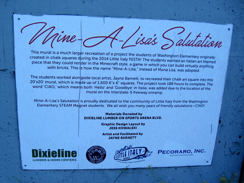
Washington Elementary students create abstract Mona Lisa chalk art during 2014 Festa in Little Italy. As you will see, it would later become the basis for a very cool public mural!
Students at Washington Elementary STEAM Magnet School in Little Italy have helped to produce a very cool public art mural! As motorists depart Little Italy, turning onto southbound Interstate 5 from Grape Street, they are greeted by a colorful Minecraft-style Mona Lisa along with the big word CIAO!
The abstract 20′ x 20′ Mona Lisa mural is based on chalk art that Washington Elementary School kids created for 2014 Festa, an annual Italian-themed festival in their very own Little Italy neighborhood.
I happened to blog about Festa that year, and took the above photo of the kids working on the original Mona Lisa chalk art. With the help of local artist Jayne Barnett, their completed work would eventually become a very large, very creative mural that thousands of delighted drivers pass every day!
Mine-A-Lisa’s Salutation. The Little Italy mural is a much larger recreation of chalk art created by students at 2014 Festa. The Italian art-themed piece was rendered using “bricks” of color in the Minecraft style.Mona Lisa says goodbye to everyone with a large CIAO as drivers head onto southbound I-5 from Grape Street!
If you’d like to see more chalk art created during 2014 Festa, including many amazing pieces produced by students from schools all around San Diego, click here!
…
I live in downtown San Diego and love to walk around with my camera! You can follow Cool San Diego Sights via Facebook or Twitter!
How time flies! Cool San Diego Sights is almost five years old!
You might not realize it, but Cool San Diego Sights now has hundreds of unique blog posts, and thousands upon thousands of fun photos that you can explore!
One easy way to revisit old blog posts that share a particular theme or subject is to click a tag. You might be surprised by all the diverse, unexpected things you’ll discover!
As you explore my blog, you might notice there’s a whole universe of tags. You can find a handful of pertinent ones located at the bottom of each post. If you’re interested in a particular San Diego neighborhood, those tags exist, too!
There’s also a handy search box that you can use. Look for it in the sidebar.
Make exciting discoveries and have fun with me as I explore San Diego! I’m going somewhere fascinating this Saturday that very few people know about!
If you’d like, you can follow Cool San Diego Sights via Facebook or Twitter!
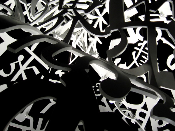
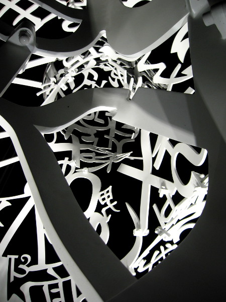
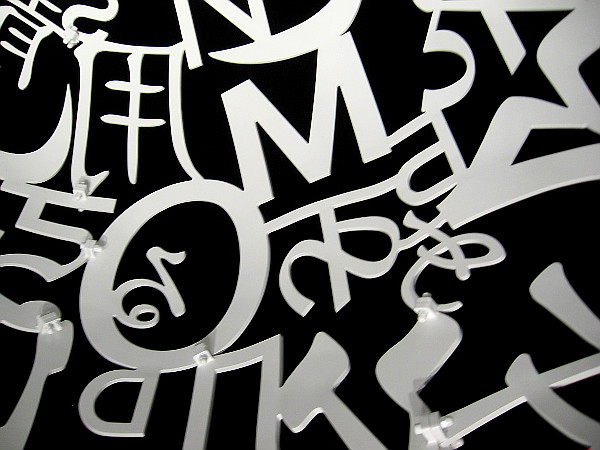
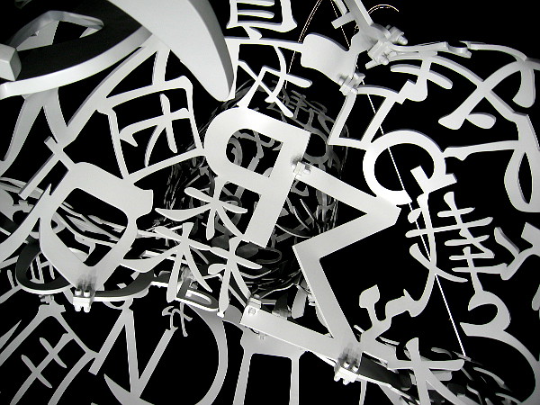
Early this morning, while it was still dark, I moved curiously around (and inside) the new Jaume Plensa sculpture Pacific Soul in downtown San Diego. Bright lights shining up from beneath the sculpture give its hollow but extremely complex form weird substance. Every angle fascinated my eyes.
If you’d like to learn more about this amazing public art, which now stands at the corner of Broadway and Pacific Highway near the Embarcadero, visit my original blog post, where several months ago, over the period of several days, I documented Pacific Soul’s installation. In that post I also provided some information about Jaume Plensa, who is a world-renowned artist from Spain.
…
I live in downtown San Diego and love to walk around with my camera! You can follow Cool San Diego Sights via Facebook or Twitter!
You can easily explore Cool San Diego Sights by using the search box on my blog’s sidebar. Or click a tag! There are thousands upon thousands of photos for you to enjoy!
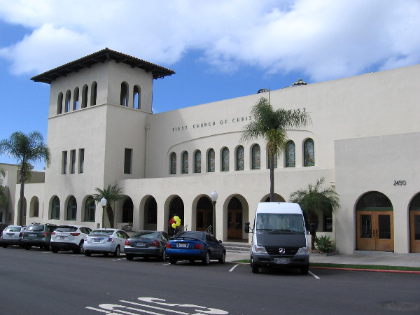
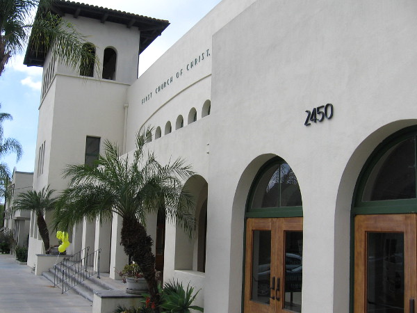
An architectural masterpiece, the First Church of Christ, Scientist building by Irving Gill.
The First Church of Christ, Scientist building, designed by renowned architect Irving Gill and completed in 1910, is considered by many to be a masterpiece. I often pause a minute or two to admire its simple, rhythmic beauty when I walk near Second Avenue and Laurel Street in Bankers Hill.
During the San Diego Architectural Foundation’s 2018 OPEN HOUSE event a couple weekends ago, I ventured inside the church for the very first time.
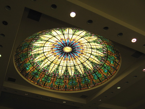
I was interested to learn that when it was completed over a century ago, the mayor of San Diego considered the building such an amazing architectural accomplishment that he showed it to visiting dignitaries. I also learned that the church underwent a “modern” remodel in the 1950’s, which removed archways, windows and the beautiful glass dome. Thankfully the building was restored to its original appearance in 1998.
To my fascinated eyes, the arches, windows and tower are elegant, like notes of music. The white stucco enhances every perfect line and curve, as if a cloud were carved precisely with the architect’s pencil.
I took some photos! Read the captions for additional information.
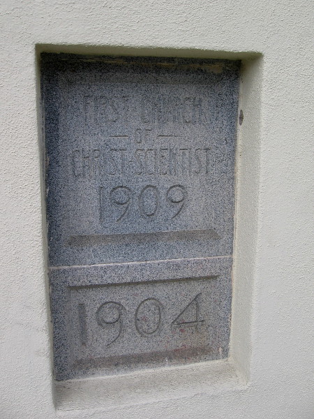
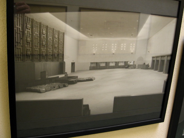
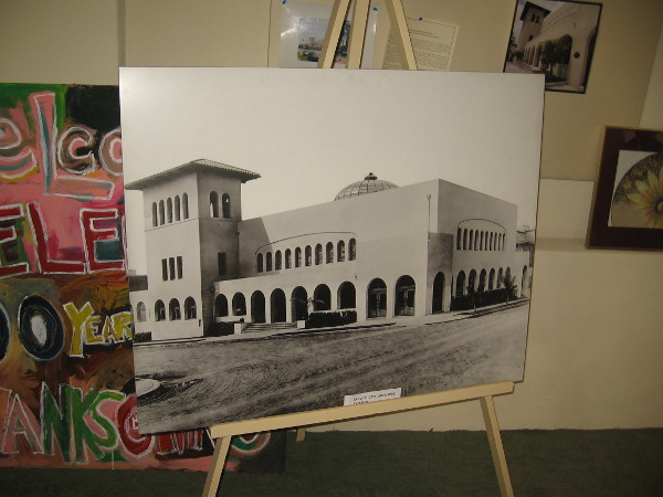
Simple arches and lines mount skyward like a cubist painting.First Church of Christ Scientist 1909. I believe the 1904 signifies the year of their first small downtown building, which stands at Third Avenue and Ash Street and is now occupied by the attorney King Aminpour.Balloons outside the entrance indicate this church is a participant in the annual San Diego Architectural Foundation OPEN HOUSE.Arched windows inside admit light and create an impression of heavenly space. I’m reminded of a jewel’s bright facets.Like a crown of gold, organ pipes dominate the altar of a light-filled sanctuary.The amazing stained glass dome above the church sanctuary.A large poster containing photographs of the building’s 1950’s appearance and historic restoration. (Click image to enlarge.)The poster’s legend. The restoration brought back much of the natural light admitted by the original archways and glass dome.Photo of the sanctuary in the 1950’s. Perhaps at the time this was considered tasteful, but today it seems very drab.Old photo of this famous Irving Gill building, the dome just visible on the rooftop.I was told these are some of the original Irving Gill blueprints. The are displayed with other documents and historical photos in a hallway near the church sanctuary.An architectural marvel in San Diego’s Bankers Hill neighborhood.
…
I live in downtown San Diego and love to walk around with my camera! You can follow Cool San Diego Sights via Facebook or Twitter!
You can easily explore Cool San Diego Sights by using the search box on my blog’s sidebar. Or click a tag! There are thousands upon thousands of photos for you to enjoy!
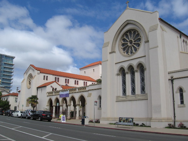
View of St. Paul’s Episcopal Cathedral from across Fifth Avenue.
I swung by St. Paul’s Cathedral in Bankers Hill a couple weekends ago during the San Diego Architectural Foundation 2018 OPEN HOUSE event. A friendly gentleman named Bob who belongs to this Episcopal church showed me the original Great Hall which was completed in 1929, then the impressive interior of the cathedral, or “big house” as he called it, which was finally completed in 1951.
St. Paul’s Cathedral was designed by architect Philip Frohman, who is best remembered as the designer of the National Cathedral in Washington, D.C. The building contains elements of both Gothic and Romanesque architecture. The original pipes of the historic church organ date from 1887. They were brought by ship around Cape Horn, to serve as the first organ in Old Town San Diego.
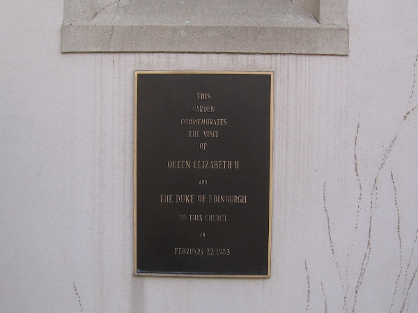
The cathedral was visited by Queen Elizabeth II in 1983 during her trip to San Diego aboard Her Majesty’s Yacht Britannia. I was told that she spoke to the congregation and enjoyed listening to Evensong.
I gleaned a few odd bits of information during the informal tour and have included them in my photo captions.
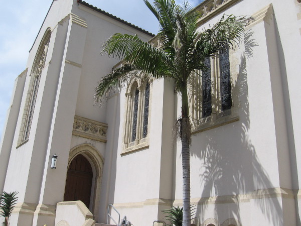
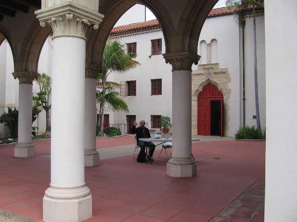
Looking north at the impressive cathedral and its many stained glass windows from Nutmeg Street.St. Paul’s Cathedral in San Diego was designed by famed architect Philip Frohman.Ladies exit through an arcade of elegant columns.A gentleman in the church’s courtyard greeted visitors during the weekend architectural event.Construction of St. Paul’s parish house or Great Hall began in 1928.The most notable thing I saw in the Great Hall is the incredible original wooden beamed ceiling, which is showing signs of age.Turning my camera for another shot of this amazing ceiling.Sunlight enters through a rose window.A plaque in the courtyard area between the Great Hall and cathedral. This garden commemorates the visit of Queen Elizabeth II and the Duke of Edinburgh to this church on February 27, 1983.Inside the beautiful cathedral, looking east from the nave toward the chancel and historic Great Organ.People have quietly entered the sacred place. The gray interior walls allow light from the stained glass lancet windows, created by Judson Studios in Pasadena, to fill the eyes of worshipers.This small Lady Chapel to the east was built in 1975. It’s used for weddings and other celebrations. It contains a smaller organ.The cathedra, or bishop’s seat, off to one side.More resplendent stained glass, like celestial visions shining through darkness.
…
I live in downtown San Diego and love to walk around with my camera! You can follow Cool San Diego Sights via Facebook or Twitter!
You can easily explore Cool San Diego Sights by using the search box on my blog’s sidebar. Or click a tag! There are thousands upon thousands of photos for you to enjoy!
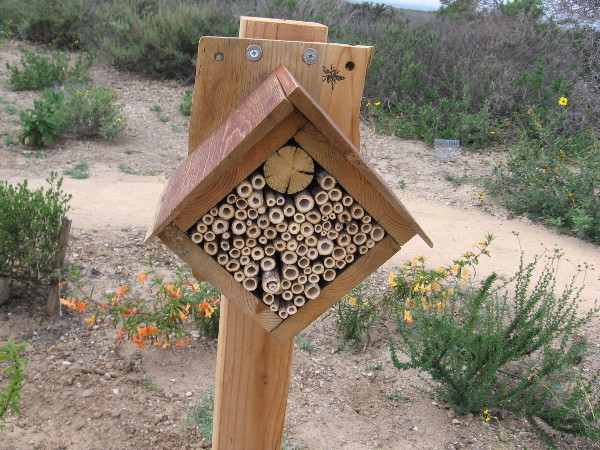
Anyone can create a beehouse for their garden. All you really need is a drill!
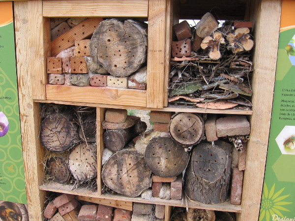
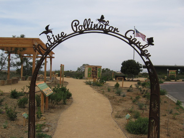
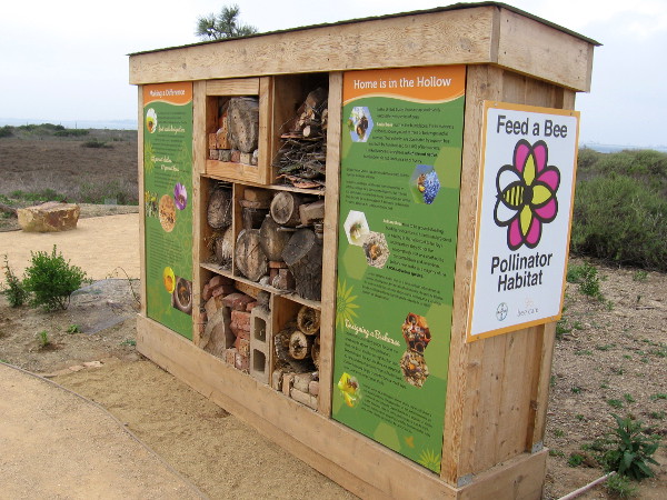
Before my hike through the Sweetwater Marsh on Saturday, I took a stroll through the Native Pollinator Garden just outside the Living Coast Discovery Center. After reading a variety of informative signs, I paused in the garden to look at some very cool beehouses!
As I read about the beehouses, it occurred to me these would be extremely easy to make.
I took photographs just in case anyone reading this blog would like to make a beehouse for their own garden! Read the captions to learn more about the habits of ground-dwelling solitary bees and the materials you can use to make them a beehouse!
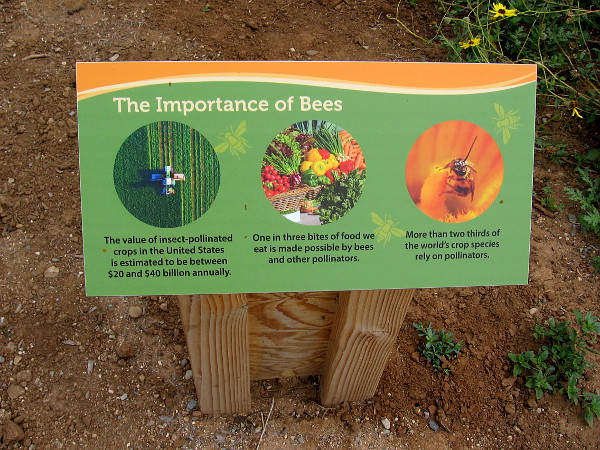
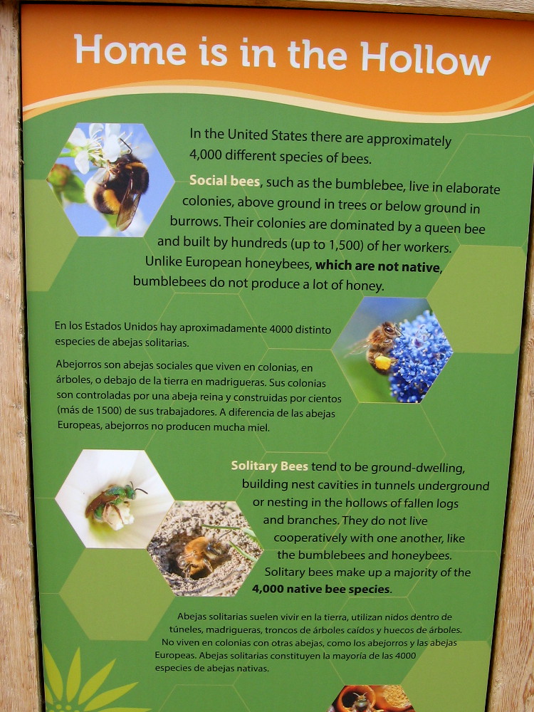
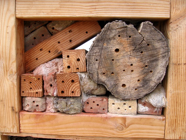
The Native Pollinator Garden just outside the Living Coast Discovery Center includes a couple of very cool beehouses!Bees are extremely important. More than two thirds of the world’s crop species rely on pollinators.A large Feed a Bee Pollinator Habitat in the native garden provides shelter for solitary bees and information for the curious.The rear of this bee condo! Holes have been drilled in a variety of materials, including logs, lumber and bricks.Solitary bees don’t live in colonies. They often seek out hollows of fallen logs, bark and branches. They make up a majority of the 4000 bee species in the United States.A close look at the fun beehouse. I think even I could make one of these.Creating various hiding places attracts solitary bees, which can be as small as an eighth of an inch.Feeling inspired? Handy with a hammer and nails? Fashion your beehouse into a unique work of art!
…
I live in downtown San Diego and love to walk around with my camera! You can follow Cool San Diego Sights via Facebook or Twitter!