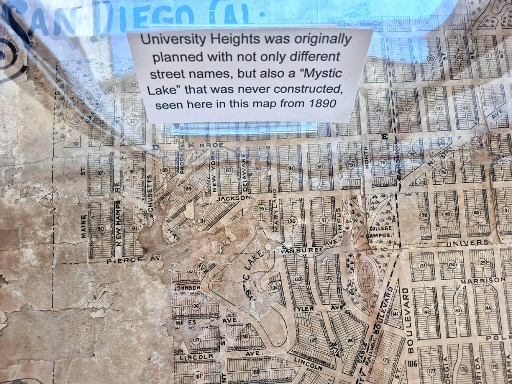

Did you know that a lake was originally planned for one of University Heights’ canyons? You’ll learn this and more should you visit the San Diego Central Library and view one of several small exhibits in the 9th floor Special Collections Center. Mystic Lake is one fascinating aspect of The San Diego That Never Was.
Looking at Google Maps today, and comparing it to the old 1890 map on display at the library, you can see how Mystic Lake would have fit into University Heights as planned in 1888. The lake’s lower extremity would have been cradled by Lincoln Avenue and Maryland Avenue. It was not to be.
As this informative webpage (which explains University Heights street names) explains: By 1906, Arch Street, Proctor Place, and New Jersey Street replaced the area originally planned to be Mystic Lake.
Mystic Lake would have been located a couple blocks directly west of the State Normal School, which was predecessor to San Diego State University. The site today is headquarters of San Diego Unified School District.
It’s interesting to see San Diego’s old cable car route on the 1890 map as a dashed line. The short-lived cable car line operated from June 1890 to October 1892. As this historical webpage explains, the San Diego Cable Railway ran from downtown San Diego north on Fourth to University, then east to present-day Park Blvd., and north to Mission Cliff Gardens.
(Today, one of those old cable cars is preserved at the National City Depot museum. Check out photographs of San Diego Cable Railway car number 54 by clicking here!)
…
To follow my blog, find the “Follow” box in this website’s sidebar. Or bookmark coolsandiegosights.com and swing on by occasionally!
(If you’re viewing this on a phone, open my website’s sidebar by tapping those three parallel lines at the top of the page.)