Life on and off the shore at Cardiff.

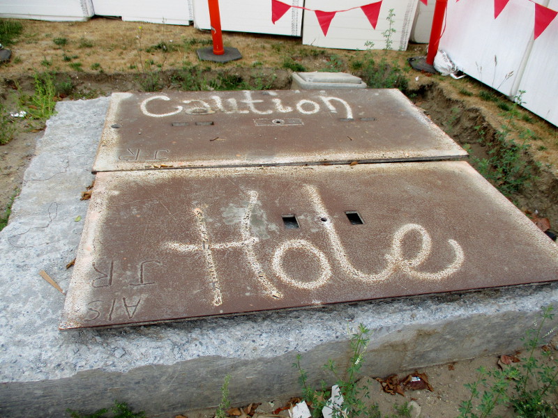
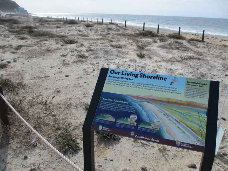
At Cardiff State Beach, in San Diego’s North County, restored coastal dunes are roped off, protecting fragile habitat from human feet.

Signs posted on the perimeter explain the “constructed dunes” and Our Living Shoreline.

One sign explains that coastal dunes provide a natural buffer against waves, tides and storms in winter.

Made resilient with native vegetation, the dunes provide important wildlife habitat and protect San Elijo Lagoon from flooding.

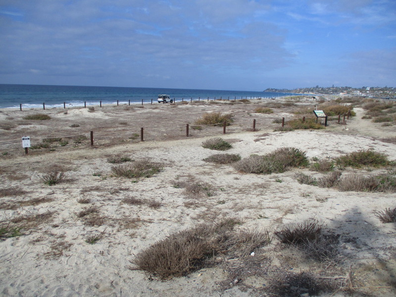
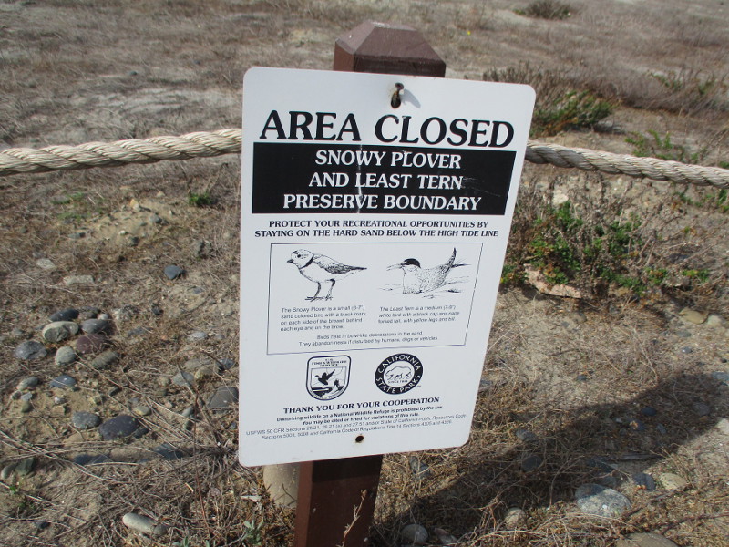
The roped dunes at Cardiff State Beach constitute a snowy plover and least tern preserve. These birds have decreasing populations, largely due to development, recreation and other human activity. The birds nest in vulnerable bowl-like depressions in the sand.

A second Our Living Shoreline sign concerns native coastal scrub and dune plants. Among these are sand-verbena, beach evening-primrose and woolly-heads.

The plants provide cover and food for native and migrating birds.

This colorful information sign, near the entrance to South Cardiff State Beach, concerns California’s kelp forests.

The underwater “Hidden Forest, Rich with Life” can be viewed from the shoreline as floating brown-green patches of seaweed.

The kelp plants hold to the ocean floor and stretch up 100 feet or more. They support an unseen world teeming with life, including diverse fish, marine mammals, sea slugs, sea stars, sea anemones and spiny sea urchins.

Thanks for visiting Cool San Diego Sights!

I post new blogs pretty often. If you like discovering new things, bookmark coolsandiegosights.com and swing on by occasionally!

I live in downtown San Diego and love to walk around with my camera! You can follow Cool San Diego Sights via Facebook or Twitter!

Walking past the forgotten town of Bernardo.

Did you know there used to be a town named Bernardo in what is now San Diego’s North County?

Bernardo was a tiny town between Escondido and Rancho Bernardo, where Lake Hodges is located today.

The creation of Lake Hodges in 1918, accomplished by damming the Bernardo River (now called San Dieguito River), put a definite end to little Bernardo. But today people hiking the Mule Hill Trail can see several information signs that recall the history of the now vanished town.

If you’d like to walk down the Mule Hill Trail yourself, take Interstate 15 to Bear Valley Parkway at the south end of Escondido. The wide dirt trail can be found about a quarter mile east of the freeway, leading south. (You’ll see it right before Beethoven Drive.)

Before reaching the site of old Bernardo, this very easy trail passes Mule Hill, where a skirmish took place during the Mexican-American War. I’ll be blogging about that coming up.

Cart roads used by the Spanish and Mexicans before the appearance of Bernardo linked a number of Ranchos–San Bernardo, El Rincon, Del Diablo, Santa Maria, Santa Ysabel, Valle de San Jose and San Felipe–with the port of San Diego.

After the division of Rancho San Bernardo around 1870, a small village developed, known as the town of Bernardo. In addition to several houses, there was a store, post office, blacksmith shop, grange hall and public school. By 1887, the population in the surrounding farm area was approximately 400 people…

For a brief period, Bernardo was a stop for the stagecoaches between San Diego and Yuma.

The San Diego to Yuma Road was an overland trail in the mid-1800s. It was used by the Army of the West in 1846 and gold rush immigrants from 1848 through 1851. It passed through tiny Bernardo as it led northeast from Peñasquitos to Ramona, eventually connecting with the Butterfield Stage Route at Warner Springs.

The history of Rancho San Bernardo began in the late 18th century when the King of Spain took possession of all land in California. In 1823, when Mexico gained its independence, the land became Mexico’s property. Don Jose Francisco Snook, a former English sea captain, received land grants from the Mexican government, including Rancho San Bernardo…

With the passing of the Mexican rancho era came the beginning of the American era, which is represented by the nearby Sikes Adobe Farmhouse. The restored farmhouse is a historic site that one can visit a short distance down the Coast to Crest Trail. (The Mule Hill Trail is a segment of the Coast to Crest Trail.)

Thanks for visiting Cool San Diego Sights!

I post new blogs pretty often. If you like discovering new things, bookmark coolsandiegosights.com and swing on by occasionally!

I live in downtown San Diego and love to walk around with my camera! You can follow Cool San Diego Sights via Facebook or Twitter!

Signs of the Holiday Season in Encinitas!

I headed back to North County today. During my walk through Encinitas, along Coast Highway 101, I noticed many signs of the Holiday Season!

Not only did I spy workers hanging holiday lights on the Golden Lotus Tower of the Self-Realization Fellowship ashram, I saw the marquee of La Paloma Theatre features Elf and Die Hard XMAS.

Along the sidewalks and in shop windows I noticed poinsettias, wreaths, Christmas trees, and even ugly sweaters!

Enjoy a few fun photos!

Thanks for visiting Cool San Diego Sights!

I post new blogs pretty often. If you like discovering new things, bookmark coolsandiegosights.com and swing on by occasionally!

It’s easy to explore Cool San Diego Sights by using the search box on this website’s sidebar. Or click a tag. There’s a lot of stuff to share and enjoy!

I live in downtown San Diego and love to walk around with my camera! You can follow Cool San Diego Sights via Facebook or Twitter!

Trains and Rails at Del Mar’s Powerhouse Park.

Visitors to Del Mar’s beachside Powerhouse Park might easily miss this very interesting sign.

The sign is unobtrusive and badly weathered and stands across the walking path from the “Tot Lot” playground. When you lean in close to read the sign, you discover it concerns the nearby railroad tracks.

If you’re lucky, while you’re standing there, an Amtrak or Coaster train, or even a freight train, might rumble by.

I had to add contrast to these photographs, to make reading the sign a little easier.

Amtrak’s Pacific Surfliner roars by, heading out onto Del Mar’s coastal bluffs. (I took this photo as I walked south of the sign through Sea Cliff Park, which is immediately adjacent to Powerhouse Park.)

Trains and Rails. Ribbons of steel that link our country.

The origins of the San Diego Northern Railway date back to the late 1880s, when Atchison, Topeka and Santa Fe Railway (AT&SF) built tracks along the Pacific coast from Orange County to San Diego…

…Several different train operators use this railroad. The NCTD carries more than 1.1 million passengers on a total of nearly 5,000 Coaster commuter trains annually. Amtrak carries more than 1.5 million passengers on more than 8,000 Surfliner trains annually. The Burlington Northern Santa Fe Railway also runs approximately 2,500 freight trains along this coastal railroad every year…

The sign contains fun facts concerning local train history, including:

On July 7, 1881, the first ship arrived in San Diego with iron rails from Europe.

On November 17, 1885, the last spike was driven in San Bernardino connecting San Diego to the national line.

The last steam train left San Diego for Los Angeles on August 23, 1953.

Thanks for visiting Cool San Diego Sights!

I post new blogs pretty often. If you like discovering new things, bookmark coolsandiegosights.com and swing on by occasionally!

It’s easy to explore Cool San Diego Sights by using the search box on this website’s sidebar. Or click a tag. There’s a lot of stuff to share and enjoy!

I live in downtown San Diego and love to walk around with my camera! You can follow Cool San Diego Sights via Facebook or Twitter!

Photos outside La Mesa’s historic McKinney House.

I took the trolley to La Mesa yesterday, eager to check out the La Mesa Historical Society’s McKinney House Museum.

I arrived at the McKinney House right at one o’clock, when it is said to open on Saturdays. After walking up and down the sidewalk taking outside photographs, it became apparent the museum wouldn’t be opening on time. So in this blog post I can only provide exterior photos of the 1908 house built by Rev. Henry A. McKinney, back when La Mesa was known as Allison Springs.

You can see an old historical photograph of the house here.

I look forward seeing the interior on a future visit. I’ve read it contains furnishings from the 1908-1920 period. I believe there are exhibits concerning La Mesa’s history, too.

Not sure why the museum sign was on the ground.

Thank you for visiting Cool San Diego Sights!

I post new blogs pretty often, so you might want to bookmark coolsandiegosights.com and check back from time to time.

You can explore Cool San Diego Sights by using the search box on this website’s sidebar. Or click a tag! There’s a lot of stuff to share and enjoy!

I live in downtown San Diego and love to walk around with my camera! You can follow Cool San Diego Sights via Facebook or Twitter!

Amusing signs from a Pacific Beach walk!

Happy Friday!

Enjoy these amusing signs I spotted during a walk in Pacific Beach, along the boardwalk, and along a stretch of Mission Boulevard and Garnet Avenue.

Many of the funny signs reflect the laid-back party vibe of this beach community. In some there’s a little wisdom, too.

Whether the witty signs were designed to catch the eyes of tourists, or the eyes of locals, doesn’t seem to matter!

Thank you for visiting Cool San Diego Sights!

I post new blogs pretty often, so you might want to bookmark coolsandiegosights.com and check back from time to time.

You can explore Cool San Diego Sights by using the search box on this website’s sidebar. Or click a tag! There’s a lot of stuff to share and enjoy!

I live in downtown San Diego and love to walk around with my camera! You can follow Cool San Diego Sights via Facebook or Twitter!

Art, oddities, and inexplicable moments!

Just a fun batch of photographs taken during various walks around San Diego.

Sometimes I’ll spy odd or unexpected things that bring a smile. And a quick click of the camera shutter…

I live in downtown San Diego and love to walk around with my camera! You can follow Cool San Diego Sights via Facebook or Twitter!

The Vintage Trolley: A Labor of Love.

Last weekend I rode the San Diego Trolley’s old PCC streetcar 530. I traveled a few stops on the Vintage Trolley’s downtown Silver Line loop.

As I looked about the interior of the restored 1940’s streetcar, I noticed a sign that I’d never seen before. Several paragraphs pay tribute to Ed Lindstrom, who was instrumental in restoring the Vintage Trolley vehicles operated by MTS.

Ed worked as a Light Rail Vehicle Project Coordinator and Electromechanic. Restoring the two streetcars that now run on the Silver Line–cars 529 and 530–required parts that are extremely difficult to find. According to the sign, Ed relentlessly sought the necessary parts from other transit agencies, collectors and museums. With some harder-to-find components, Ed got creative. He reverse-engineered and produced them specifically for the project!

To learn more about the PCC streetcar restoration, and see photos of how the old cars once looked, click here!

If you ever ride one of these nostalgic streetcars on a weekend, you can thank Ed and many others who’ve worked countless hours making a beautiful dream come true.

A LABOR OF LOVE.

Operation of the vintage streetcars in San Diego…began as a dream of Harry Mathis… A cadre of volunteers, led by our restoration manager, Dave Slater, has contributed more than 11,000 man hours of work on our fleet of PCC’s…

As a resident of downtown San Diego who loves riding the Vintage Trolley cars, thank you!

I live in downtown San Diego and love to walk around with my camera! You can follow Cool San Diego Sights via Facebook or Twitter!

Star Trek’s 10 Forward warps into Gaslamp!

Star Trek has warped into San Diego’s Gaslamp Quarter!

The saucer section of Enterprise must have separated, and landed somewhere near Fifth Avenue, because I see 10 Forward is to be temporarily relocated to Happy Does!

Paramount+ is bringing STAR TREK’S 10 FORWARD: THE EXPERIENCE to 2022 Comic-Con, and visitors will be able to possibly rub elbows with Guinan while drinking cocktails. It all happens at 340 Fifth Avenue. But right now, as I blog this, it appears to be sold out.

But good news! Outside, on the Happy Does patio, people will be able to freely experience an offsite concerning Star Trek: Picard! No Comic-Con badge required I was told!

Engage!

If you’d like to view my coverage of Comic-Con so far, which includes hundreds of cool photographs, click here!

I live in downtown San Diego and love to walk around with my camera! You can follow Cool San Diego Sights via Facebook or Twitter!

A strange California Historical Landmark . . . parking lot?

At the north corner of Congress Street and Twiggs Street, in San Diego’s Old Town, you’ll find a large parking lot.

In a strip of landscaping between the parking lot and sidewalk stands a mysterious sign. The sign reads: SITE OF CASA DE COTA – HISTORICAL LANDMARK NO. 75.

That’s strange! The only thing visible is the parking lot! So, where is Casa de Cota?

According to this page of the San Diego History Center: Built in the mid-1830’s by Juan or Ramón Cota, this house stood for over a century on the corner of Twiggs and Congress Streets, before being destroyed by United States Army bulldozers during World War II.

You can see two old photographs of the historical structure here and here.

It appears to have been built of adobe blocks.

Visitor maps posted around Old Town San Diego State Historic Park show Parking Lot B, where the house once stood. I’ve included the following photo. I marked a red X at the mysterious sign’s location.

Do you happen to know more about the long-vanished Casa de Cota? If you do, please leave a comment!

I live in downtown San Diego and love to walk around with my camera! You can follow Cool San Diego Sights via Facebook or Twitter!