Amazing walk up the historic Helix Flume Trail!

Breathtaking views and unique history can be enjoyed during a hike on the Helix Flume Trail in Lakeside.

In 1889 a 35-mile long wooden water flume was completed that brought water from Lake Cuyamaca in San Diego’s East County into the rapidly growing city.

This morning I enjoyed an amazing walk up the historic Helix Flume Trail in Lakeside!

The moderately easy hiking trail begins at the old El Monte Pump Station, climbs a nearby hillside with a series of short steep switchbacks, then follows a short, mostly level section of the historic flume’s route. Information signs describe the construction and history of the engineering marvel, and hikers are able to see the entrance to one of the flume’s old tunnels!

As you will observe in the following photographs, the walk includes some fantastic vistas and natural beauty.

Come along with me and read the photo captions to learn much more…

Looking toward the trailhead of the historic Helix Flume Trail.
Looking past a large shady tree toward the trailhead of the historic Helix Flume Trail.
The old El Monte Pump Station is located next to the small parking lot by the trailhead to the Helix Flume Trail.
The old El Monte Pump Station is located next to a small parking lot by the trailhead to the Helix Flume Trail.
The El Monte Pump Station was originally built in 1898 to lift well water to the flume on the hillside using steam powered pumps.
Photograph of the historic pump station in Lakeside, California.
Photograph includes huge pipes outside the historic pump station in Lakeside, California.
Plaque by door of El Monte Pump Station dated 1937, when a major overhaul was finally complete. Water was then pumped from the El Capitan Reservoir.
Heading toward the trailhead and some information signs concerning the flume.
Heading toward the trailhead and an information sign concerning the flume.
One of several signs along the trail that describe the construction and history of the famous water flume.
The blue line on this topographic map is where the flume water descended as it flowed west to the growing city of San Diego.
Photograph of the wooden water flume next to old Highway 80 in El Cajon Valley.
Diagram of cross section of wooden flume box from 1913.
As I started up the trail, I looked back. The Helix Water District has a nearby lot with modern pipes and equipment.
As I started up the trail, I looked back toward the parking lot and its big tree. The Helix Water District has a nearby lot with modern pipes and equipment.
Heading up short but steep switchbacks, with rugged mountains in the distance.
Heading up short but steep switchbacks, with power lines overhead and rugged mountains in the distance.
Hikers must stay on the trail due to the historical importance of this area.
Looking down toward the pump station and El Monte Road. An old pipeline that ascends from the station is visible in this photo.
Looking down toward the pump station and El Monte Road. An old rusty pipeline that ascends from the station is visible in this photo.
Climbing higher. Wear sturdy shoes if you go on this hike. If it's hot, bring plenty of water.
Climbing higher. Wear sturdy shoes if you go on this hike. If it’s hot, bring plenty of water.
I've gained more elevation on the switchbacks. The hillside is dotted with many prickly pears. That's Hanson Pond in the distance.
I’ve gained more elevation on the switchbacks. The hillside is dotted with many prickly pears. That’s Hanson Pond in the distance.
Higher we climb!
Higher we climb!
A fence conceals an old pipeline that ran from the El Monte Pump Station to the flume.
Interesting rock outcroppings.
A beautiful view of the El Monte Valley below.
A better view of Hanson Pond.
The climb is over. We approach another information sign where the old hillside pipeline terminates.
An amazing view of rocky mountains across the valley opens up here.
Sign describes the struggles to supply water. The open flume had troubles with massive leakage due to rot, and evaporation.
In 1915, a court ordered Ed Fletcher to repair the leaky flume. He lined it cheaply with asphalt roofing material using a rolling tar wagon.
San Diego County Park Ranger shows a section of wooden flume pipe.
The open, wooden flume was eventually replaced with covered conduit and pipe. In 1962, the pump station began to send water to the newly created Lake Jennings.
A flag flies near the information sign.
The trail continues along the flume's old route.
The trail continues along the flume’s old route.
Turning a corner, with rugged El Cajon Mountain (El Capitan) in the distance.
Some natural beauty by the hiking trail.
This is mountain lion country. A sign describes what to do should you encounter one.
Entering mountain lion country. A sign describes what to do should you encounter one.
I spot a third information sign down below, at the end of a short path.
I spot another information sign down below, at the end of a short path.
A short distance from the sign is the entrance to the Monte Tunnel.
The flume needed eight tunnels along its slowly descending route. The Monte Tunnel was the fifth tunnel from the flume's water source, Lake Cuyamaca.
The flume needed eight tunnels along its slowly descending route. The Monte Tunnel was the fifth tunnel from the flume’s original water source, Lake Cuyamaca.
Diagram on the sign shows the dimensions of each tunnel.
The tunnel entrances had decorate facades of cut and mortared local granitic boulders.
The bottom 1887 photo shows construction of the seventh tunnel. Part of the eventually outdated tunnel system was destroyed by Navy SEALS for training.
The barred Monte Tunnel entrance photographed during my hike.
I took this flash photograph into the tunnel. After the flash I heard a curious low noise, like that of an animal.
A fourth sign can be found nearby, where the Helix Flume Trail connects with the Lake Jennings trail system.
Another information sign can be found nearby, where the Helix Flume Trail connects with the Lake Jennings trail system.
San Diego residents were thrilled at the flume's completion in 1889. There was a parade and a fountain of water. But it wasn't flume water. There was a blockage somewhere up the line!
San Diego residents were thrilled at the flume’s completion in 1889. There was a parade and a fountain of water. But it wasn’t flume water–it was well water! There was a blockage somewhere up the line!
San Diego's historic water flume was considered such an engineering triumph that it was featured on the cover of Scientific American.
San Diego’s historic water flume was considered such an engineering triumph that it was featured on the cover of Scientific American.
Today little remains of the flume. But the natural beauty of this area in San Diego's East County endures.
Today little remains of the flume. But the natural beauty of this area in San Diego’s East County endures.

I live in downtown San Diego and love to walk around with my camera! You can follow Cool San Diego Sights via Facebook or Twitter!

You can easily explore Cool San Diego Sights by using the search box on my blog’s sidebar. Or click a tag! There are thousands upon thousands of photos for you to enjoy!

Morning walk by the San Diego River estuary.

Early this morning, light and life were both rising along the San Diego River estuary.

I didn’t walk far along the water–perhaps a quarter mile west from the Interstate 5 bridge.

I live in downtown San Diego and love to walk around with my camera! You can follow Cool San Diego Sights via Facebook or Twitter!

Fantastic ikebana exhibitions in Balboa Park!

Today I got lucky!

I stumbled upon two different ikebana exhibitions while strolling about Balboa Park!

The first show I enjoyed was being held inside the Casa del Prado. Sogetsu San Diego Branch had filled a large room with many fantastic Japanese flower arrangements.

The Sogetsu School of ikebana originated in 1927. This school of floral arrangement allows for wider individual expression than traditional ikebana, which adheres to formal rules.

According to what I read in a brochure at the show: Sogetsu Ikebana can be created anytime, anywhere, by anyone in any part of the world, and with any kind of material.

You can see in a few of the upcoming photographs that some rather strange materials are indeed used!

The second show I enjoyed was being held inside the Exhibit Hall at the Japanese Friendship Garden. Fantastic arrangements had been created by the Ohara School of Ikebana, La Jolla Chapter.

A friendly artist explained that the Ohara School often creates a sense of natural landscape with flowers and common plants, like grasses, ferns, holly and even garden vegetables! Wide basins and water can enhance the sense the viewer is hovering above a wild garden or beautiful lake.

The careful design of each arrangement incorporates at least one triangle. You can see several of those triangles in my photos:

I live in downtown San Diego and love to walk around with my camera! You can follow Cool San Diego Sights via Facebook or Twitter!

Help build the San Diego River Discovery Center!

Look what I discovered today!

While driving down Qualcomm Way, I noticed a couple of new signs by the San Diego River indicating that “The San Diego River Discovery Center at Grant Park” is coming to Mission Valley!

The San Diego River Discovery Center at Grant Park is a project of the San Diego River Park Foundation. The following is an overview taken from their website:

“Imagine a place that provides hands-on science based nature education and experiences to 25,000 kids each year! For many of these kids, it will be their very first experience!

Imagine a place which celebrates the San Diego River as an important ecological resource and inspires the next generation of River and nature stewards.

In May 2009, this vision of a new place where people could enjoy and connect with the San Diego River took a major step forward when the San Diego River Park Foundation signed a donation agreement with a remarkable family, the Grants. This longstanding San Diegan family decided to donate their 17-acre river-fronting property to benefit the community of Mission Valley and San Diego in general.

With this inspiring action, the San Diego River Discovery Center at Grant Park was born.

This 17-acre site is in the heart of Mission Valley. Prominently located at the northeast corner of Qualcomm Way and Camino del Rio North, the site is easily accessible by foot, bicycle, trolley, bus and automobile.

Grant Park is being designed to serve as a nature-based park, learning center and a gateway to exploring our San Diego River.”

All the legal hurdles to begin grading have been cleared–now the San Diego River Park Foundation just needs to raise some additional funds.

After work I walked around the general area where the park and nature center will be built and took photos.

To learn how you can make a donation, click here!

I live in downtown San Diego and love to walk around with my camera! You can follow Cool San Diego Sights via Facebook or Twitter!

Torrey Pines Extension hike to the DAR plaque.

This morning I enjoyed an incredible (and relatively easy) hike along several short trails through Torrey Pines State Natural Reserve’s less-visited Northeastern Extension.

I started from the trailhead at the northeast end of Del Mar Scenic Parkway and, watching for rattlesnakes, climbed north along the Mar Scenic Trail to the DAR Trail.

When I reached the trail junction where one turns to reach the DAR plaque, I elected to continue west downhill for a short distance, just to enjoy the amazing scenery. Beyond picturesque Torrey Pine trees stretched the wide blue Pacific Ocean and Torrey Pines State Beach.

Finally I retraced my steps, turned north on the West Ridge D.A.R., and made my way to the historic DAR plaque.

It reads:

TORREY PINE STATE RESERVE

D A R TRAIL AND MEMORIAL GROVE

THIS TRAIL AND MEMORIAL GROVE
ARE DEDICATED TO OUR PLEDGE TO SAVE
AND FAITHFULLY DEFEND FROM WASTE
THE NATURAL RESOURCES OF OUR COUNTRY.
ITS SOILS, MINERALS, ITS FORESTS,
WATERS AND WILDLIFE.

THE CALIFORNIA STATE SOCIETY
OF THE
NATIONAL SOCIETY
DAUGHTERS OF THE AMERICAN REVOLUTION
MRS. LEROY CONRAD KAUMP, STATE REGENT
NOVEMBER 16, 1971
U.S.A. BICENTENNIAL PROJECT

What a fantastic walk!

Unlike the very popular main section of Torrey Pines State Reserve, which is located to the south across Los Penasquitos Lagoon, it’s possible you won’t encounter another human being while hiking through this small area of protected wilderness. Wear sturdy shoes or boots because the sandy path can be a bit slippery. And bring some water. It can get pretty warm!

Enjoy the following photos!

I live in downtown San Diego and love to walk around with my camera! You can follow Cool San Diego Sights via Facebook or Twitter!

You can easily explore Cool San Diego Sights by using the search box on my blog’s sidebar. Or click a tag! There are thousands upon thousands of photos for you to enjoy!

Natural beauty near the Sikes Adobe.

Early this morning, before the summer sun could make hiking very hot, I enjoyed a slow, quiet walk near the Sikes Adobe Historic Farmstead in Escondido.

I followed the Coast to Crest Trail for a bit, passed over Kit Carson Creek, and gazed off toward the willows and sycamores that line the edge of Lake Hodges and the San Dieguito River.

I lifted my camera when my eyes happened to perceive another instance of natural beauty.

I live in downtown San Diego and love to walk around with my camera! You can follow Cool San Diego Sights via Facebook or Twitter!

Music like shadow and sunlight in leaves.

This evening I enjoyed another extraordinary concert of the 2019 San Diego International Organ Festival.

In a groundbreaking musical performance, San Diego Civic Organist Raúl Prieto Ramírez was joined on stage by a symphonic string quartet. Kathryn Hatmaker and Wesley Precourt played violin; Hanah Stuart played viola; and Alex Greenbaum played violoncello. The result was nothing less than brilliant.

The highlight of the concert was a sublime performance of César Franck’s Piano Quintet in F minor, transcribed by Raúl Prieto Ramírez for the organ.

The resonant voice of the Spreckels Organ and the yearning quality of the strings combined to bring forth exquisitely complex emotions. Bittersweet joy and heartbreak flowed together. The notes were rich with passion and tinged with regret. A whole lot like life.

A standing ovation concluded the evening.

Before the concert began in Balboa Park’s Spreckels Organ Pavilion, I walked through the nearby Japanese Friendship Garden.

When I saw my photographs of the garden’s natural beauty, it occurred to me that the music this evening was much like shadow and sunlight in leaves.

The rare magic produced this evening was the result of three San Diego treasures coming together: the world-class San Diego Symphony with its many talented musicians, one of the world’s most accomplished organists, and the Spreckels Organ, one of the most amazing musical instruments in the world.

May this magic become a tradition.

Mural at Civita celebrates San Diego!

Ranches, hot air balloons, the San Diego Zoo Safari Park.

There’s a very cool mural inside a pedestrian tunnel at the Civita development in Mission Valley. I recently learned about this public art because it was nominated for a 2019 Orchid Award by the San Diego Architectural Foundation.

The 72-foot-long mural, which can be found under Via Alta next to the Civita Dog Park, was painted in 2018 by local artist and muralist Kevin Anderson. It depicts well-known and beloved places in the city of San Diego and the surrounding county.

San Diego County is so enormous, it’s geographic area is larger than Rhode Island and Delaware put together! Looking at this beautiful mural, you can see the county’s fantastic natural diversity, from the oceans to the mountains and deserts, not to mention San Diego’s rich history and culture.

Because this mural isn’t far from my work, I couldn’t resist walking over today to check it out!

Here are photos that you might enjoy!

View of the pedestrian tunnel that passes under Via Alta in Civita Park. The mural inside depicts many wonderful places around San Diego.
Outside view of the pedestrian tunnel that passes under Via Alta in Civita Park. The mural inside depicts many wonderful places around San Diego.
The Blue Angels, citrus and agriculture, San Diego County mountains, golf.
The Blue Angels, citrus and agriculture, the mountains of San Diego County, golf.
Potato Chip Rock, mountain biking, rural living.
Julian apple pie, wildlife and wildflowers, the Palomar Observatory.
Mountains overlooking Anza-Borrego Desert State Park, cacti, bighorn sheep.
Beneath San Diego State University and Balboa Park, Civita Park has been painted in Mission Valley, along with the names of Civita Kids Art.
Junior Seau, Tony Gwynn, Petco Park, downtown and San Diego Bay.
USS Midway, Coronado Bay Bridge, Star of India, Hotel del Coronado.
Little Italy, USS Midway, Coronado Bay Bridge, Star of India, Hotel del Coronado.
Mariachis of Old Town beneath the Serra Museum, SeaWorld, Mission Bay.
La Jolla Cove and Pacific Ocean aquatic life.
Surfing and paragliding along the cliffs of Torrey Pines.

I live in downtown San Diego and love to walk around with my camera! You can follow Cool San Diego Sights via Facebook or Twitter!

A summer whale watching trip in San Diego!

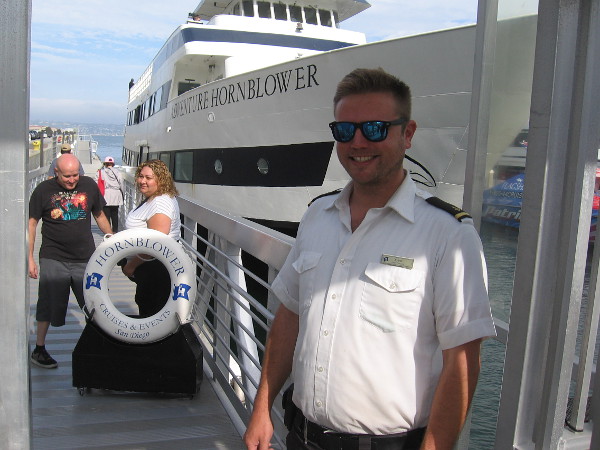
Wow! Talk about a fun summer adventure! Today, thanks to Hornblower Cruises and Events, I enjoyed a summer whale watching trip out in the beautiful Pacific Ocean off San Diego!

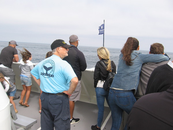
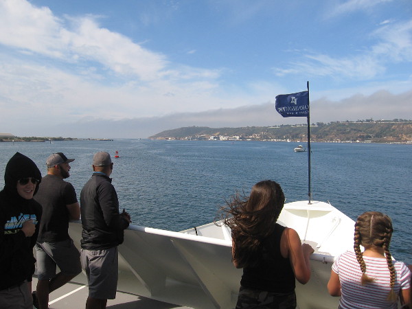
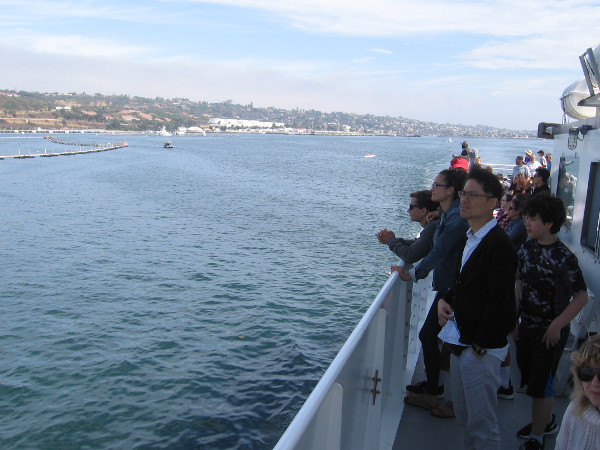
I and other passengers aboard the Adventure Hornblower cruised out of San Diego Bay and continued many miles west of Point Loma in search of blue whales, the largest animal on planet Earth.

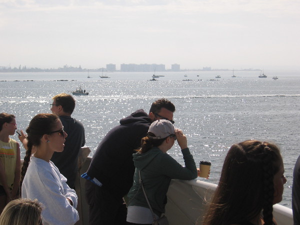
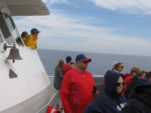
Spotting these enormous mammals, which move through the oceans in a constant pursuit of food, can be a hit or miss proposition, but it was such a sunny, perfect day and the wide ocean was so calm and blue, I didn’t really care what we might happen to discover!

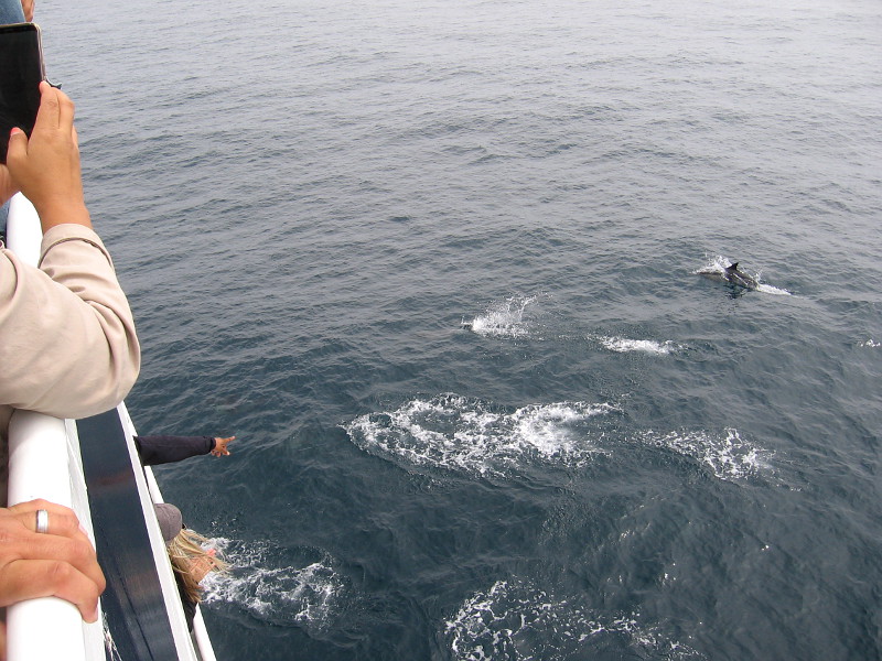
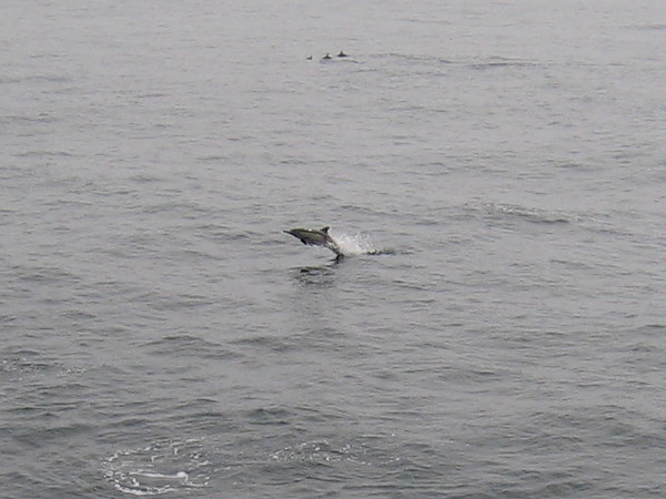
We did see numerous pods of dolphins almost everywhere we turned. They fed and played in the gentle swells nearby, and didn’t seem to mind the big ship full of pointing humans passing overhead.

I took lots of photos, but dolphins break the surface unexpectedly then quickly melt back into the water, so my small camera just managed to get a few decent pics. You have to be there to feel the excitement, not to mention the fresh wind and bright sunshine. It’s an incredible, magical experience!

Had this been a winter whale watching trip, we would likely have seen gray whales as they migrate along the California coast to and from Mexico. During the summer it’s possible to spot a variety of other whales, including blue whales and humpback whales, but these species don’t follow a predictable route of migration.

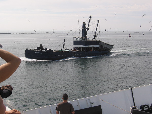
Our captain took us a good distance out into the open ocean. All hands searched the horizon when we reached the Nine Mile Bank–an underwater mountain range teeming with sea life where blue whales often feed. On our way out we spotted the distant spout of a Fin Whale–the second-largest species on Earth–but were unable to successfully see it up close.

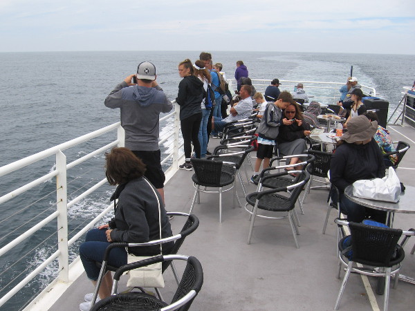
On our way back to San Diego we approached another boat that might have sighted a whale. We turned off our motor and silently drifted in, watching carefully, but we saw only dolphins and a group of feeding gulls and pelicans. The other boat had a drone hovering over the water, but it didn’t seem to find what it was looking for.

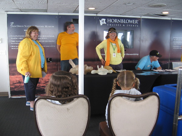
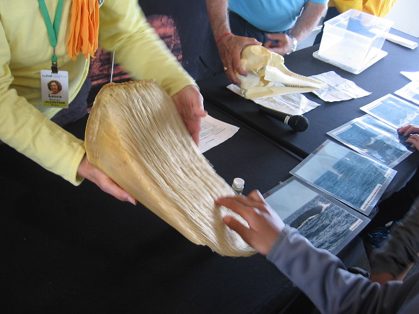
As we neared the channel into San Diego Bay, friendly people from the San Diego Natural History Museum in Balboa Park gave a short educational presentation, complete with close up photos of blue whales, an example of the filter-like baleen that these huge whales use to collect four tons of tiny krill per day, and a toothy dolphin skull. Kids enjoyed learning about all the cool marine life and had many questions!

I should mention, the summer whale watching trip included a narrated tour of the north part of San Diego Bay, where you always see something new. Including sea lions! It’s just as fun and interesting as a regular harbor cruise.

Because we didn’t spot a whale today, every passenger got a voucher for another free whale watching trip, or a harbor cruise on San Diego Bay. You can bet I’ll use mine!

Find out more about this awesome four hour summer whale watching adventure by visiting Hornblower’s San Diego website here!

IMG_1922x

I live in downtown San Diego and love to walk around with my camera! You can follow Cool San Diego Sights via Facebook or Twitter!

You can easily explore Cool San Diego Sights by using the search box on my blog’s sidebar. Or click a tag! There are thousands upon thousands of photos for you to enjoy!

More of nature’s beauty in Mission Valley.

This morning I got off the trolley in Mission Valley earlier than usual, so I walked around.

Please enjoy a few photograph’s of nature’s beauty.

I walked down a path through landscaping near the Hazard Center trolley station, along a short segment of the San Diego River Trail, then turned north at Mission Center Road to head to work.

I live in downtown San Diego and love to walk around with my camera! You can follow Cool San Diego Sights via Facebook or Twitter!